Geology, Prospecting and Exploration for Iron Ore Deposits
Geology, Prospecting and Exploration for Iron Ore Deposits
Iron has been known since antiquity. Iron is ubiquitous in the lithosphere as either a major constituent or in trace amounts. In abundance it ranks fourth behind oxygen, silicon and aluminum.
Iron ores have a wide range of formation in geologic time as well as a wide geographic distribution. These ores are found in the oldest known rocks in the crust of the earth, with an age in excess of 2.5 billion years, as well as in rocks formed in various subsequent ages. In fact, iron ores are even forming today in the areas where iron oxides are being precipitated.
Several thousands of iron occurrences are known throughout the world. They range in size from a few tons to several hundreds of millions of tons. Iron ore deposits are distributed in different regions of the world under varied geological conditions and in different geological formations. The largest ore concentration is found in banded sedimentary iron formations of Precambrian age. These formations constitute the bulk of iron ore resources of the world.
Iron ores occur in a wide variety of geological environments in igneous, metamorphic or sedimentary rocks, or as weathering products of various primary iron bearing materials. Iron ores can be grouped into types of similar geological occurrence, composition and structure. The following is a simplified classification which is based on genesis of the deposits and geological environment. It shows the main modes of occurrence of iron ores as well as it illustrates the varied geology of iron ore deposits.
- Igneous ores -These iron ore deposits are formed by crystallization from liquid rock materials, either as layered type deposits that possibly are the result of crystals of heavy iron bearing minerals settling as they crystallize to form iron rich concentrations, or as deposits which show intrusive relationship with their wall rocks. These ore deposits are either tabular or irregular and are composed largely of magnetite with varying amounts of hematite. Igneous ores are usually high in iron content and are often high in phosphorus or titanium content.
- Contact ores – Iron ore deposits formed at or near the contact between igneous rocks and sedimentary rocks are normally composed of magnetite and hematite with associated carbonates and pyrite. The ore deposits are usually in the sedimentary rocks as irregular or tabular replacement bodies.
- Hydrothermal ores – These are iron ore deposits formed by hot solutions which transported iron and replaced rocks of favorable chemical composition with iron minerals to form irregular ore bodies. In these deposits, iron often occurs as siderite (FeCO3) or sometimes as oxides.
- Sedimentary ores – These are (i) bedded ores, (ii) siderite ores, (iii) placer ores, or (iv) bog iron ores. ‘Bedded iron ores’ are often composed of oölites of hematite, siderite, iron silicate or, less commonly, limonite in a matrix of siderite, calcite or silicate. These ores have a wide geographic distribution associated with other sedimentary rocks and often have a fairly high phosphorus content. The ores may be self fluxing. ‘Siderite ores’ consist of beds of siderite or siderite nodules associated with shales. They are common in the coal measures and are often termed clay ironstones or black band ironstones. These ores usually contain associated sulphides and often have a fairly high sulphur and phosphorus content. Iron oxides, when compact, are usually resistant to weathering and erosion and under favorable conditions may form ‘placer deposits’ which, in a few instances, constitute iron ores. Placer deposits are of minor importance as sources of iron. ‘Bog iron ores’ occur in many swampy areas. They occur normally as dark brown, cellular masses, or granular or fine particles of limonite. These ores have long ago ceased to be of importance commercially.
- Metamorphosed iron formations – These include the metamorphosed bedded ferruginous rocks composed usually of alternating thin layers of fine grained quartz and ferric oxides. The iron is normally present in the mineral form of magnetite or hematite, along with lesser amounts of iron silicates and iron carbonates. Essentially all of the Precambrian sedimentary iron formations are of this type. The metamorphosed types also include those in which the original form of the ores has been obscured by extensive recrystallization. Some of these iron formations are important economically as iron ores because of their amenability to beneficiation by fine grinding and by concentration of the ore minerals principally by magnetic methods.
- Residual ores – These ores are usually products of the surficial weathering of rocks but may include ores formed by hydrothermal oxidation and leaching. Ores of this type were formed extensively in Precambrian iron formations by leaching of silica, which commonly constituted in excess of 50 % of the rock. Oxidation changed iron carbonate, silicate minerals, and magnetite to hematite or limonite.
The potential iron ore known to exist in an area is called iron ore resource. Identified resources include both reserves and other iron bearing materials that may become profitable to mine under future economic conditions. Identified resources are those whose location, grade, quality and quantity are known or estimated from specific geologic evidence. Identified resources include economic, marginally economic and sub-economic components, and depending upon the degree of geologic certainty, each of these economic divisions can be further subdivided into measured, indicated and inferred. Reserves are defined as those resources that can be economically mined at the time of their determination.
Exploitation of existing iron ore deposit is the easier part of the mining operations. The harder part is to find new ore deposits and to define their extent and the iron content (grade). Exploration is the process by which the accumulations of iron ore minerals can be found in the earth’s crust. Before the heavy investments required to set up a mining operation is done, the mining organization is to ensure that the deposit is economically viable and it has quantities of ore that will ensure ore production over a sufficiently long period of time. Even after production starts, it is necessary to locate and delineate any extensions to the mineralization, and to look for new prospects that may replace the reserves being mined. Investigating extensions, and searching for new deposits, are vital activities for a mining organization.
Prospecting involves searching an area for mineral deposits with the view to mine it at a profit. In other words to transform the mineral deposit into an ore deposit. A geologist prospecting an area is looking for surface exposure of minerals, by observing irregularities in colour, shape or rock composition. His experience tells him where to look, to have the greatest chances of success.
Exploration, while it sounds similar to prospecting, is the term used for systematic examination of a ore deposit. . It is not easy to define the point where prospecting turns into exploration. After an interesting area is chosen, an application for exploration permit is made. Approval by officials is needed before exploration activities can commence.
Activities related to prospecting and exploration
The first step in the activities relates to prospecting and exploration is to conduct a review of historical and existing data, especially from closed down mines and core samples and other relevant information available from earlier exploration which can be accessed. This can result in great savings in time and money required for new activities. One of the cheapest phases of area exploration is preparation of a comprehensive, detailed and accurate geological map which often starts with basic instruments such as tape and compass. The accuracy can be enhanced by using air photos to help locate outcrops, major fault zones and basic topographic control. Each step adds some more costs, but it also improves the accuracy and details of the resulting map.
Land which is soil covered is inaccessible to the prospector, who first look out for an outcrop of the mineralization. Where the land cover comprises a shallow layer of alluvial material, trenches are usually dug across the mineralized area to expose the bedrock.
A prospector identifies the discovery, measure both width and length, and estimate the mineralized area. Samples from the trenches are analyzed in the laboratory. Even when minerals can be found on the surface, determining any extension in depth is a matter of qualified guesswork. If the prospector’s findings, and his theorizing about the probable existence of an ore deposit are on solid ground then the next step is to explore the surrounding land.
Exploration is a term embracing geophysics, geochemistry, and finally the more costly activities viz drilling into the ground for obtaining samples from any depth. Fig 1 shows the general activity sequence in prospecting and exploration of an ore deposit. Efficient exploration depends on increasingly sophisticated map production for planning purpose and access routes, for geological, geophysical, geochemical and structural mapping. Today detailed aerial topographic maps are available giving the explorer basic information to determine where to find areas with good potential of ore deposit.
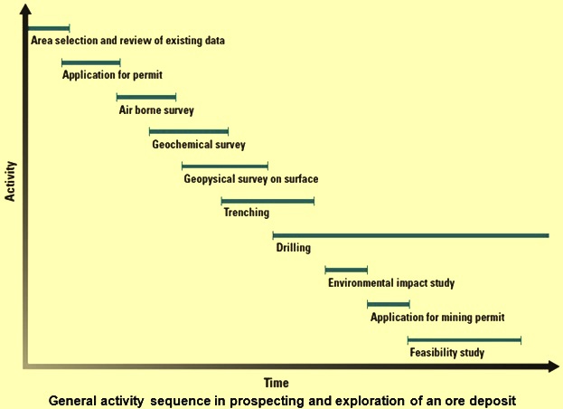
Fig 1 General activity sequence in prospecting and exploration of an ore deposit
Geophysical exploration
After their introduction in the 1950s, airborne geophysical surveys have become a commonly used first step in geophysical exploration. Large areas can be effectively covered in a short period of time. The most common aero geophysical maps are magnetometer maps which record the variations in the earth’s magnetic field with high degree of accuracy. The optimal selection of altitude and spacing as well as choice of instrumentation are important in an airborne geophysical surveys.
From surface, different geophysical methods are used to explore subsurface formations, based on the physical properties of rock and iron bearing minerals such as magnetism, gravity, electrical conductivity, radioactivity, and sound velocity. Two or more methods are often combined in one survey, to acquire more reliable data. Results from the surveys are compiled, and matched with geological information from surface and chips or core samples from any previous core drilling, to decide if it is worthwhile to proceed with further exploration. In case the survey results points towards further exploration then the information form basis for the drilling activities. As geophysical survey is normally conducted from the air to begin with, information from the surface surveys are compared and added to the airborne mapping.
Present geophysical techniques and instrumentation, sampling methods, drilling procedures, and some methods of geological investigation as applicable for iron ore are described below. Geophysics, as applied to iron ore explorations, is primarily a reconnaissance tool that provides information that must subsequently be complemented by geological mapping, petrographic studies, drilling and the evaluation of ore analyses and treatment tests. The geophysical techniques used in the search for iron ores, as in most geophysical mapping, are based upon the presence of measurable contrasts of physical properties between the ore minerals and the surrounding rocks. The physical properties used principally are magnetism (both permanent and induced) and density. Electrical methods (including polarization and electromagnetism) and seismic studies are used sometimes in conjunction with magnetic or gravity surveys to obtain better definition of the ore bodies.
Magnetometers
Modern magnetometers have greater sensitivity and convenience of operation. Because it, since 1950s, they have eliminated other methods such as the dip needle and super dip from practical employment in exploration of iron ore. Magnetometers have passed through several successive stages of development. The principal forms as being known, in the order of their conception, are balance type, torsion type and flux gate magnetometers, followed in recent years by magnetometers that were conceived and developed in the field of atomic physics. These latter instruments include the rubidium vapour, proton-precession and optical absorption magnetometers.
Magnetometers are used to determine the strength of the earth’s magnetic field or its vertical component at a given location. The earth’s field is very weak, ranging from about 0.7 oersted at magnetic poles to about 0.25 oersted at some points on the magnetic equator. In geomagnetic studies, field strength is measured in a much smaller unit than the oersted, which is the gamma (equal to 0.00001 oersted). The shape of the earth’s magnetic field is not uniform, but shows large scale regional irregularities due to variations in the shape and composition of the crust and upper mantle of the earth. Variations on a smaller scale result from magnetic disturbances caused by concentrations of magnetic material near the surface and it is these local variations that are sought when iron ores are searched.
Magnetic surveying
Magnetic survey measures variations in the earth’s magnetic field caused by magnetic properties of subsurface rock formations. The airborne magnetometer is the primary geological tool used in the search for iron ores and iron bearing materials in large areas. The method of conducting an airborne magnetic survey is to install a flux gate or proton precision magnetometer in an airplane which traverses the target area at a fixed altitude and along predetermined flight lines. The magnetometer measures the magnitude of the earth’s magnetic field. The data is recorded electronically along with the position of the airplane and its altitude. In recent years, there is improvements in the quality of the surveys due to the refinements in the equipment that include greater sensitivity and simplicity, multiple channel data recording, miniaturization of instruments and a more accurate positioning capability. Because of the presentation and recording of the data in digital form, computers are used for carrying out the necessary data reduction and plotting requirements needed for analyses and interpretation. Data from these records are plotted as a contour map, with lines connecting points of equal magnetic intensity on the map. The patterns formed by these lines indicate areas where magnetic anomalies (major local distortions of the earth’s magnetic field) occur. The areas indicated by anomalies on the magnetic map are then investigated in greater detail by geological surveys and by gravity measurements, electromagnetic studies or other geophysical techniques. These geophysical techniques are given below.
Electromagnetic surveys are based on variations of electric conductivity in the rock mass. A transmitter is used for creating a primary alternating electromagnetic field. Induced current produces a secondary field in the rock mass. The resultant field is traced and measured, thus revealing the conductivity of the underground masses.
Electric surveys measure either the natural flow of electricity in the ground, or galvanic current led into the ground and accurately controlled. Electrical surveys are used to locate mineral deposits at shallow depth and map geological structures to determine the depth of overburden to bedrock, or to locate the groundwater table.
Induced polarization surveys are conducted along grid lines with readings taken at receiving electrodes planted in the earth and moved from station to station. The electrodes are connected to a receiver and measure the chargeability (the capacity for various minerals to build up a charge of electricity) and resistivity effects on current forced into the ground and bedrock.
Gravimetric surveys measure small variations in the gravitational field caused by the pull of underlying rock masses. The variation in gravity may be caused by faults, anticlines, and salt domes that are often associated with oil-bearing formations. Gravimetric survey is also used to detect high density minerals such as iron ore.
In regions where rock formations contain radioactive minerals, the intensity of radiation is considerably higher than the normal background level. Measuring radiation levels helps locate deposits containing minerals associated with radioactive substances.
Seismic surveys are based on variations of sound velocity experienced in different geological strata. The time is measured for sound to travel from a source on surface, through the underlying layers, and up again to one or more detectors placed at some distance on surface. The source of sound might be the blow of a sledgehammer, a heavy fallen weight, a mechanical vibrator or an explosive charge. Seismic survey determines the quality of bedrock and can locate the contact surface of geological layers, or of a compact mineral deposit in the ground.
In case of iron ores, the detailed magnetic study of anomalous areas may involve using a magnetometer in a helicopter, or ground surveys employing hand-held or other portable magnetometers. A new electromagnetic prospecting technique known as AFMAG (audio frequency magnetics) has been used in areas where magnetic anomalies have been detected to attempt to differentiate between buried deposits of volcanic glass or low grade iron bearing intrusives and deposits with high remanent magnetization that represent potential ore bodies. The rubidium vapour magnetometer, likewise, makes possible the rejection of non economic deposits by differentiating between magnetic deposits, high in magnetic susceptibility and electrical conductivity, and buried volcanic glass and low grade non conducting iron bearing intrusives of low susceptibility which, however, are capable of producing attractive magnetic anomalies.
Sampling and drilling
In the early period of iron ore discovery, most of the exploration of potential ore bodies was done by test pits and shafts. These days correlation and evaluation of the detailed data from magnetometer or other surveys is usually followed by a carefully worked out drilling program to provide samples that, through geological and mineralogical studies, establish the kind, quality and extent of ore that may be present, and the nature and quantity of the overburden or rock formations associated with the ore.
Considerable attention is given these days for the improvement of core drilling methods to provide better samples. The most complete and undisturbed drill sample possible at a reasonable cost is the ultimate goal. Diamond drills are employed especially in hard formations. The use of drilling muds with diamond drills has been adopted where samples of the highest quality from alternately hard and soft banded material are desired. Rotary down hole drills and reverse circulation drills of several types can provide a rapid rate of penetration with satisfactory sample recovery in some sampling applications. Wire line drilling is employed in about half of the core drilling operations in some parts of the world. The statistical evaluation of the results of exploration drilling is done to provide guides for planning drilling programs, especially with regard to the most economical spacing of holes and the most desirable degree of core recovery that would provide adequate sampling at the lowest cost.
The next and most expensive part of the exploration sequence is drilling. For a driller, all other exploration methods are like beating about the bush. Drilling penetrates deep into the ground, and brings up samples of whatever it finds on its way. If there is any mineralization at given points far beneath the surface, drilling can give a straightforward answer, and can quantify its presence at that particular point. The expenditure for drilling comprises about half of the total exploration costs. There are two main methods of exploratory drilling namely core drilling and percussion drilling.
Core drilling, yields a solid cylinder shaped sample of the ground at an exact depth. Percussion drilling yields a crushed sample, comprising cuttings from a fairly well determined depth in the hole. Beyond that, the drill hole itself can provide a complementary amount of information, particularly by logging using devices to detect physical anomalies, similar to the geophysical surveys mentioned above.
Core drilling is used to define the size and the exact boundaries of mineralization. This is important for determining ore grades being handled, and vital for calculating the reserves of the ore. A strategically placed underground core drilling can also intersect new ore bodies in the neighbourhood. The core is an intact sample of the underground geology, which can be examined thoroughly for the determination of the exact nature of the rock and any mineralization. Samples of special interest are sent to a laboratory for analysis to reveal the content of the iron in the ore.
Cores from exploration drilling are stored in special boxes and kept in archives for a long period of time. Boxes are marked to identify from which hole, and at what depth, the sample was taken. The information gathered by core drilling is important.
To obtain fast geological information at less costs, reverse circulation methods are sometimes used. Instead of core samples, the geologist gets access to drill cuttings (chips) throughout the hole length which are checked and mapped for mineral content after laboratory analyses. Reverse circulation drilling is fast becoming popular for surface drilling applications. The rigs in the reverse circulation method are truck mounted and restricted to accessible terrain and better road conditions as compared with core drilling equipment, which are readily disassembled.
From prospecting to mining
For the quantification of the mineralization, and for defining the shape, size and metal content of the deposit, step by step procedure is needed in the exploration activities. At every step of the procedure, the information at hand is examined, to decide whether continuation of the exploration efforts is needed. The objective is to be fairly certain that the deposit is economically viable by providing a detailed knowledge of the geology of the deposit. Ore is an economic concept, defined as a concentration of minerals, which can be economically exploited and turned into a saleable product.
Before a mineral deposit can be labelled as an ore body, full knowledge is required about the mineralization, proposed mining technology and processing methods. The environmental impacts of mining and mineral processing are to be carefully studied and it needs approval. A prerequisite for investing in the mining operation is the confidence needed for the sustained profitability over a long period of time. At this stage a comprehensive feasibility study is undertaken covering capital requirements, returns on investment, payback period and other essentials. Based on all geological documentation and the study the mining organization gets a good idea of how to mine the deposit.

Leave a Comment